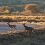
Field research on elk, cougars, and rattlesnakes reveals what it will take to reconnect Appalachia with wildlife crossings.
A Diverse Ecological Tapestry
Golden light spills over the Blue Ridge Mountains, casting the silhouette of a bull elk across the road as he trots towards it. Wood thrushes and Carolina wrens call across the valley. Sunlight glints off his thick coat, his antlers, the black GPS collar at his neck. He pauses, sniffing the air, then slips back into the tree line and vanishes among the hemlocks. Around the bend, a truck’s engine grows louder. Some animals make it across. Others don’t. It’s a daily gamble, playing out across a rewilding Appalachia threaded with roads.
Appalachia is a diverse ecological tapestry, woven across thousands of miles, from the rocky headlands of Quebec’s Gaspé Peninsula to the upland hardwood foothills of northeast Mississippi. The Great Smoky Mountains alone hold the highest salamander diversity on the planet, and perhaps the most dense black bear population in the eastern United States (rivaled only by the Alligator River National Wildlife Refuge). The Appalachian region is home to more than 250 species of birds, 78 species of mammals, and 134 species of reptiles and amphibians.
It is one of the most biodiverse temperate regions on Earth and a critical migratory corridor for wildlife. Traffic through this mountain region makes it increasingly difficult for wildlife to safely navigate their habitat, and at the same time, abundant wildlife makes the roads more dangerous for drivers. Our field research projects in Appalachia help us understand these challenges and how to advocate for solutions.

I-40 freeway road leading to Asheville in North Carolina over Appalachian mountain pass with yellow fall forest and fast moving trucks and cars. Concept of high speed interstate transportation.
Returning to a Range Threaded with Roads
Elk are one of Appalachia’s great conservation comeback stories, but the story isn’t finished. After being absent from much of the region for more than a century, they are once again moving through Appalachian forests, fields, and mountain valleys. The challenge now is ensuring that these restored herds have enough connected habitat to grow, disperse, and thrive.
Populations like the one in and around Great Smoky Mountains National Park remain small, isolated, and slow to grow, so every animal lost to a vehicle collision is a real setback for genetic diversity, on top of the danger a large animal poses to drivers.
Starting in 2018, Wildlands Network researchers and partners fitted 13 elk with GPS collars and tracked them for the next two years, gathering more than 123,000 location points along four major roads: the Blue Ridge Parkway, I-40, US-19, and US-441.
A clear pattern emerged. Elk avoided major roads, sticking to smaller ones whenever possible. But when they crossed, it was overwhelmingly along the Blue Ridge Parkway and US-19, which together accounted for roughly four out of every five recorded crossings. But that avoidance has limits. When a road stands between an elk and the resources it needs, the elk crosses anyway. Cow elk #30216 shows just how often that can happen.

Elk #30216 crossing I-40 with her calf, using an underpass that is part of the Appalachian Trail.

A map of the journey made by Elk #30216. The orange line indicates her movement.
Both years we tracked her, #30216 made the same remarkable journey. Each spring, she left Great Smoky Mountains National Park and traveled about 10 miles to a secluded mountain valley to give birth.
Over those two years, she crossed Interstate 40 more than 50 times, and our GPS data and cameras captured her returning to the park with her calf through an underpass along the Appalachian Trail. Her story illustrates both the risks elk face when moving across a road-fragmented landscape and the importance of preserving safe routes between habitats.
Roads influence how elk navigate this landscape, and major highways can create barriers between important habitat areas. By mapping where elk repeatedly cross roads and combining that information with elk use, road characteristics, and collision data we can identify where crossings can make the biggest impact. It’s what these elk need to go from restored to self-sustaining.
 Liz Hillard
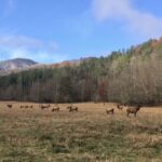
 The elk herds within the Appalachian region are small and still recovering.
Providing Safe Passage for a Keystone Species
Appalachia hasn’t had a resident cougar population in over a century. There’s evidence that could change. In the past three decades, there have been 300 cougar sightings east of the Mississippi, a wave of dispersal that’s edging closer to a landscape cougars haven’t called home since the early 1900s, when hunting and habitat loss wiped them out across the region and most of the eastern United States.
As a keystone species, cougars can influence entire ecosystems — shaping how prey like deer move and use habitat, providing carcasses that feed scavengers, and returning nutrients to the landscape. Their return to Appalachia could help restore ecological relationships that have been missing for more than a century. But recolonization would depend on connected habitat that allows cougars to disperse, establish territories, and move through the landscape while minimizing conflict with people.
In a study published in 2022, Wildlands Network and its research partners identified large areas of potential cougar habitat across eastern North America, including substantial habitat within the Appalachian region. This research also modeled potential dispersal routes throughout the region, including routes connecting Florida’s remaining panther population with core habitats to the north. These routes should not be interpreted as intact or proven wildlife corridors – they pass through a patchwork of suitable habitat, developed land, agricultural areas, and dangerous road networks.
“That potential depends on habitat connectivity: without it, this keystone species will struggle to disperse naturally and avoid conflict with communities.”
Our current research builds on that continental-scale model to more closely examine potential dispersal routes through the Appalachians at a finer scale, identify critical gaps and road barriers, and determine where habitat protection, restoration, wildlife crossings, and improved agency management tools and capacity could support natural dispersal.
Evidence that cougars can reach these landscapes already exists. In 2015, DNA from a hair sample collected in western Tennessee identified a female cougar genetically similar to animals from South Dakota. Although the discovery did not signal the return of a breeding population, it demonstrated that at least one female cougar had reached much farther into the species’ former eastern range than many expected. Her journey offers hope with a caveat: natural recolonization may be possible, but only if cougars can safely move between the habitats they need to survive.
Other cougar populations show what happens when those connections are lost. The Florida panther’s story is a cautionary tale: habitat loss and fragmentation contributed to severe isolation and inbreeding, eventually requiring genetic rescue through the introduction of female cougars from Texas. Roads continue to impede their movement and cause deadly vehicle collisions.
A similar pattern is unfolding in Southern California, where highways and urbanization have isolated small mountain lion populations and reduced genetic diversity. Together, these cases show that suitable habitat alone is not enough: cougar populations also need safe, functional connections among habitat areas to remain genetically healthy and persist over time.
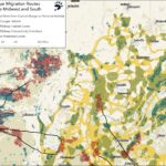
A map of likely eastern cougar migratory routes through the Midwest to the Appalachian Foothills.
Safe Passage for Wild Neighbors
Not every animal that needs to cross a road is the size of an elk or a cougar. For snakes, turtles, salamanders and small mammals, even a relatively narrow road can be an enormous barrier. These animals travel close to the ground, may move more slowly, and are often nearly invisible to drivers. Some avoid roads altogether, dividing habitat and limiting movement between populations; others attempt to cross and are killed before reaching the other side.
Timber rattlesnakes have moved through these mountains far longer than the roads have. Each year, they may travel between winter dens to summer habitats they use for foraging, breeding, and gestation. Roads can interrupt those movements through direct mortality or avoidance, gradually reducing connectivity between already small and isolated populations. For a long-lived species that matures slowly and reproduces infrequently, the cumulative loss of adults can have lasting consequences.
At Gorges State Park, Wildlands Network researchers and partners are evaluating a smaller-scale solution: four modest culvert underpasses, tucked beneath the park road with cameras at every opening. Since June 2022, the cameras have run day and night from June to November, and the team has since sorted through over 700,000 photographs.

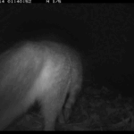


The structures were designed with timber rattlesnakes and eastern box turtles in mind, but the cameras have revealed a far longer guest list. Copperheads, garter snakes, salamanders, and newts used the passages, and so did bobcats, long-tailed weasels, wood rats, spotted skunks, and even a red fox on its way back from a successful chipmunk hunt. Structures intended to help a few vulnerable species turned out to provide passage for a much broader wildlife community.
The next step is to better understand how the crossings function. Funnel fencing can help guide more animals toward the entrances, while new interior camera systems added this year will better confirm their use by salamanders and harder-to-detect species. What we learn can help inform similar, relatively low-cost crossing projects at places such as Pisgah View State Park and eventually contribute to a broader strategy for roads that fragment wildlife habitat across Appalachia.

Our camera traps photographed many of the Timber Rattlesnake's wild neighbors using the culvert crossings.
Putting Science to Work for Wildlife
Rewilding Appalachia doesn’t stop at bringing wildlife back; it also means making sure animals can move through the landscape safely and that roads do not undermine decades of conservation progress.
Wildlands Network and the National Parks Conservation Association took on that challenge in the Pigeon River Gorge, along 28 miles of I-40 at the Tennessee–North Carolina border.
The highway cuts through more than 1 million acres of connected habitat spanning Great Smoky Mountains National Park and the Pisgah and Cherokee National Forests.
By combining more than two decades of wildlife-vehicle collision records with roadside cameras, cameras at existing structures, and movement data from GPS-collared elk, researchers identified where road crossing structures should be prioritized and turned those findings into 21 recommendations for making the roadway safer for wildlife and drivers alike.
The most important result was not simply a map of where animals were being killed. It was a clearer picture of where wildlife still try to move through the gorge and where existing infrastructure could be adapted to help them. That gives transportation agencies and conservation partners a starting point for deciding where fencing, bridge improvements, culvert retrofits, or new crossings could have the greatest impact.
It also provides a model for other Appalachian roadways. Rather than waiting for collisions to accumulate, agencies can use wildlife movement, habitat, and mortality data together to anticipate conflicts and design solutions before more habitat connections are lost.
The goal of this work is to turn data into decisions. Leave roads unchanged, and habitat will become increasingly fragmented as traffic and development grow. Build with wildlife movement in mind, and elk can reach habitat more safely, small animals can move between populations, and future dispersing species such as cougars will face fewer preventable barriers to returning to their native habitats.
Wildlife crossings will not solve every conservation problem on their own. But combined with habitat protection, fencing, land stewardship, and stronger wildlife protections, they can help preserve the connected Appalachian landscape that wildlife and people depend on. The science tells us where connectivity matters most, and who benefits. Now it’s a matter of building it.

Liz Hillard
Related Posts
 Wildlands Network
  Andrew Johnson