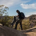
Near Joshua Tree National Park, two rescue dogs are sniffing out mountain lion and bobcat scat to help us understand how Highway 62 divides wildlife populations, and how crossings can reconnect them.
Meet the Desert Detectives
As dawn washes over the iconic Joshua trees and creosote-dotted hills of the Mojave, Siska and Merlin’s workday has already begun. They’re not park rangers or trail guides. They’re field techs of the canine variety: rescue dogs turned conservation detection dogs with Rogue Detection Teams, here to sniff out scat from two of the desert’s most elusive residents, mountain lions and bobcats.
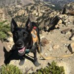
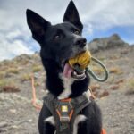
At first glance, the two are easy to mix up. Both have black coats with bright white chest blazes that would stand out against the pale desert floor even without their high-visibility orange harnesses. Look closer and you’ll see Siska is a little larger, while Merlin has a white diamond on the back of his neck. Merlin, a three-year-old border collie mix, is newer to the team. In just two seasons of fieldwork, he’s tracked the scent of mountain lions, Columbian black-tailed deer and coastal martens, among other species. Seven-year-old Siska has been at it about twice as long. She’s searched wind-energy facilities, worked on research into the endangered Sierra Nevada red fox and joined a range of other wildcat projects.
The pair weaves across sandy washes and up rocky slopes each survey day for up to seven hours. They turn into the wind, circle back and chase odors no human can detect. Their human partners, called Bounders, follow close behind and watch for every shift in their dogs’ behavior. In a desert fragmented by roadways, Merlin and Siska’s noses are important conservation tools, gathering clues that can show how wildlife moves through a landscape cut in half by a highway.
 Forktailed Media
Siska, one of the two dogs who is working on the SR 62 Study.
 Forktailed Media
Merlin, another canine tech working on the SR 62 Study.
Mountain Lions, Bighorn, and the Highway in Between
You might be wondering why we’re using scat-sniffing dogs at all. Imagine the landscape we’re working in – rocky slopes and sandy washes stretching for miles, where everything fades to the same dusty tan. Finding a 4-inch scat here is like finding a needle in a haystack, but what it could tell us makes the effort worthwhile.
The western end of Joshua Tree National Park is made up primarily of the Little San Bernardino Mountains. A sometimes rolling, sometimes rugged canyon-filled range that extends across 40 miles from State Route 62 southeast toward the park’s southern entry point. Its southwest-facing slopes are dotted with creosote, white bursage, and mound-like brittlebush that lights up the hills with a golden yellow when blooming. On its north-facing slopes, we find a milder climate and a fragrant, woodland mix of juniper, Joshua tree, and pinyon pine.
Before SR-62 was built, the Little San Bernardino Mountains were connected to the San Bernardino Mountains. Wildlife could move freely across 10,000 feet of elevation, from low desert to high alpine habitat, and through every shift in climate and plant community along the way. This transition zone was identified in the early 2000s as an important landscape linkage – a place that acts as a bridge between communities and core habitat, in this case for people as well as wildlife. The Serrano and Cahuilla people have and continue to live in and move between the foothills and upper mountain slopes to use and steward the landscape.
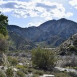
The study area spans Sand to Snow as well as Joshua Tree National Park.
Together, these two mountain ranges harbor over 400 kinds of vertebrates. It’s a diverse region with a high concentration of imperiled species where roads are a big part of what is putting them at risk. These unique ecosystems in parks like Joshua Tree and Sand to Snow have become destinations for sightseeing and recreation in the Morongo Basin. This popularity has caused traffic volumes to hit 25,000 vehicles per day, and the linkage’s role in the landscape to come under threat.
For species that rely on large, connected landscapes, effects have started to emerge. Mountain lion populations here show signs of low genetic diversity, and animals attempting to find mates between populations are often struck and killed on SR-62 and other major roads. This isolation has led to the state listing many southern lion populations as threatened. Desert bighorn sheep also rely on movement between mountains to keep smaller populations going, and the species healthy and resilient within the region. Both sides of this linkage experience challenges – from wildfires to droughts – making movement an important lifeline.
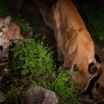 Dan Potter, Transition Habitat Conservancy
Mountain lions photographed in the San Gabriel Mountains, part of the Transverse Ranges which include the San Bernardino and Little San Bernardino Mountains.
Wildlife Crossings and the Stories Scat Can Tell
A coalition of local groups are working toward a solution. Two wildlife overpasses and fencing are currently being planned with funds from the Wildlife Conservation Board and Coachella Valley Mountains Conservancy. Our partner Mojave Desert Land Trust has lead the way in protecting this linkage for years to prepare for this next step. The wildlife crossing structures are expected to restore some of the lost function of this connected landscape for many species and improve road safety for the local and visiting drivers through the Morongo Basin.
Since the identification of this linkage, additional studies have both confirmed its importance to wildlife but also documented signs of its decline. Two stretches of SR-62 have stood out as particularly strong barriers to wildlife movement due to a lack of existing underpasses suitable for the species that live in the area and the high traffic volumes and concrete medians that make crossing the road at-grade a deadly endeavor. Wildlife road mortality concentrates at both locations and includes over 14 unique species struck. The crossings will be designed for both locations, which have proven to have up to a 96% reduction in wildlife-vehicle strikes and allow diverse species safe passage over dangerous roads.
Over time wildlife that find and use the crossings can provide new genetic material to populations that show concerning signs of isolation. It can take just a single successful journey per generation to bring a species back from extinction. It can also prevent common species from getting close to the brink in the first place.
“Did a young, dispersing male lion from Joshua Tree make his way safely into the foothills of the San Bernardinos and find love? You’d be amazed at the stories scat can tell.”
This process has yet to be well-documented, with a few notable exceptions from the iconic Banff and I-90 wildlife crossings in Washington state. Wildlands Network, along with our partners from Rogue Detection Teams and genetic researchers at Oregon State University and the California Department of Fish and Wildlife, aim to add to the small number of genetics-based studies on wildlife crossings.
Using non-invasive DNA collection methods that rely primarily on scats and hair samples instead of captures and blood draws, we plan to document the story of these crossings down to the molecular level, starting with how this highway currently affects wildlife movement and genetic exchange between populations. After the crossings are built, we can repeat the process to look for improvements. Did a young, dispersing male lion from Joshua Tree make his way safely into the foothills of the San Bernardino’s and find love? You’d be amazed at the stories scat can tell.
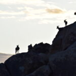
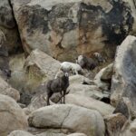
Desert bighorn also called the mountains surrounding SR 62 home.
Where the Trail Leads Next
Which brings us back to Siska and Merlin, wagging their tails at a newly found scat. While I’m traipsing ridgelines searching for desert bighorn pellets, a conservation canine and biologist tag team from Rogue will scour the washes and low slopes for bobcat and mountain lion scat. We’ll both be targeting areas predicted to support these species to increase our chance of success in the upcoming fall and winter months.
Through our collective efforts, we’ll start to piece together the current baseline for these species, showing how they’re affected by a highway built without them in mind. We’ll examine what their genes tell us about the road’s impact and, in the future, look for signs of improvement, like cross-highway pairings and signs of new genes travelling where they couldn’t before. This will take a sustained, multi-year effort before and after the crossings are built.
That’s where we need help from you and foundations interested in supporting science that can not only support the need for more wildlife crossings but can help us start to predict the impacts crossings have on the long-term health of wildlife populations. These data can help managers at state and federal agencies better plan conservation strategies and needed actions to allow our wild neighbors like bighorn sheep, bobcat, and lions to thrive alongside us.
Help Us Stay On the Trail
Science like this takes years of commitment before and after crossings are built, and it depends on gifts from supporters like you who believe in keeping wild places connected.
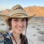
Christina Aiello, Ph.D. | California Wildlife Biologist, Wildlands Network
Related Posts
 Andrew Johnson
  Ron Sutherland