
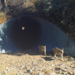
From the world’s largest wildlife crossing over US 101 to three new overcrossings planned for I-15, wildlife crossings in California are moving from concept to concrete, and our updated database maps where that progress is happening and where it’s still needed.
As the first resource of its kind to document existing and planned infrastructure designed specifically for terrestrial wildlife movement, our California Wildlife Crossing Database provides a tool for policymakers, planners, land managers, researchers, and the public. First released in 2021, the California Wildlife Crossing Database provides the most comprehensive source for existing and planned wildlife crossings in California. This summer, we completed a substantial update with new crossing information and map features.
The interactive database helps visually demonstrate the scale and distribution of wildlife crossing efforts across the state, identify regions where investments are concentrated or lacking, and track the growing integration of wildlife crossings into California’s transportation network. Where available, individual crossing records also link to relevant environmental review and planning documents and project pages, providing additional context on how projects were developed and why, the partners involved, and the planning and permitting processes that helped bring them to fruition.
This year, we added several new layers that include jurisdictional and administrative boundary layers, including Caltrans Districts, CDFW Regions, counties, and state and federal legislative districts. These additions more clearly show how wildlife crossing projects align with political and management boundaries. These boundaries provide valuable context for planning, policy, development, funding decisions, and stakeholder engagement efforts related to connectivity.
We also enhanced the visibility of Caltrans priority wildlife crossing locations, displaying them in a distinct color so users can more easily identify these sites. These priorities were identified by Caltrans pursuant to the Safe Roads and Wildlife Protection Act (AB 2344), co-sponsored by Wildlands Network and Center for Biological Diversity, which calls for coordination with the California Department of Fish & Wildlife.
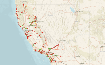
See What’s New
Read on to learn about the biggest changes, and see all the newest crossings connecting the Pacific Wildway on our database at the link below.
Tracking Wildlife Crossings in California
Since the last database update in 2025, California has continued to take meaningful strides, with wildlife crossing projects moving from concept to planning, from planning to construction, and from construction to completion. Below are just a few examples of the work underway to help save lives on both sides of the windshield.
 Caltrans
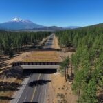
US 97 Overcrossing, located on U.S. 97 in Siskiyou County near Grass Lake.
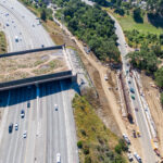
Wallis Annenberg Wildlife Crossing construction over US-101 Freeway in Agoura Hills.
1. California completes its first wildlife overpasses on the State Highway System
Caltrans has built not one but two wildlife overcrossings this year. While California’s first wildlife overcrossing was the Clinton Keith Wildlife Crossing, this was built on a county road. The two new overcrossings are the first of their kind in the State Highway System.
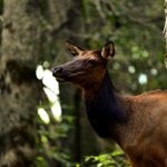
- State Route 97 Elk Overcrossing: In a project area with the highest recorded wildlife-vehicle conflict rate in the region, this wildlife crossing will reduce the frequency of wildlife-vehicle collisions and help connect the local population of Roosevelt Elk. Within a day of its completion, CDFW captured deer using the crossing, which will continue to help more deer, elk, and other wildlife safely cross the road.
- Wallis-Annenberg Crossing: The US 101 has been identified as one of the most significant barriers to ecological health in the region. The Wallis-Annenberg Crossing will reconnect protected land and improve connectivity for a local, threatened mountain lion population amongst a plethora of other wildlife species. Once officially completed in December 2026, it will be the largest wildlife crossing in the world.
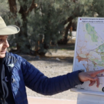
Wildlands Network's California Wildlife Biologist, Christina Aiello, speaks at a site visit for the I-15 Crossing.
2. Planning begins for three new crossings on I-15
When I-15 was initially constructed in the 1950s, it divided habitat for desert species like bighorn sheep. With the development of the new Brightline West high-speed rail system, there came an opportunity to reconnect habitat and mitigate negative effects on wildlife and the existing highway. The Brightline West project will connect Las Vegas to Socal with a high-speed rail system while the state constructs three overcrossings along I-15 to provide safe paths for wildlife. Planning is currently underway, with construction slated to begin at the end of 2026.
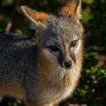
A grey fox (Urocyon cinereoargenteus) photographed in Northern California, one of the species that Caltrans has linked to a potential wildlife crossing at Mill Creek on Route 36 in Tehama County.
3. Caltrans identifies new project priorities to improve wildlife connectivity
In July 2026, the Caltrans wildlife crossing inventory identified 17 new crossing locations, including this location in Tehama County on Route 36, located within an area recognized by the California Essential Habitat Connectivity Project and CDFW. This site was identified as a priority barrier affecting numerous species, including gray wolf, Sierra Nevada Red Fox, Cascades Frog, and Roosevelt Elk.
While these projects await funding, inclusion in the inventory represents an important first step. Caltrans notes that these locations have been evaluated as transportation-aligned wildlife connectivity needs and are being considered for future planning, funding, and implementation opportunities. This establishes a pipeline of projects that can advance as funding becomes available.
Help Keep Wildlife Moving
This database is one part of Wildlands Network’s work to reconnect habitat across North America. Your support helps us build the California Wildlife Crossing Database and keep it free, advocate for new crossings, and protect wildlife corridors across North America.
The Wildlife Crossing Database was made possible through the generous support of Wildlife Conservation Network (WCN), whose investment helped launch the project and has continued to support subsequent database updates. This support is critical to help ensure that planners, agencies, researchers, and the public have access to the most current information available on wildlife crossings and connectivity priorities throughout the state.
The Wildlife Crossing Database focuses on terrestrial wildlife crossings and does not track fish passage projects unless they also provide connectivity benefits for terrestrial species. Projects were identified through reviews of CEQA documentation, state and federal grant awards, agency reports, and other public records, with information cross-checked against available data from Caltrans, CDFW, and project partners. While we strive to make the database as accurate and comprehensive as possible, some projects may be missing or contain outdated information. If you spot an error or know of a project we should include, please complete this feedback form. We’d love to hear from you and will review submissions for future updates.
Wildlands Network
Related Posts
 Forktailed Media
 Andrew Johnson
 Ron Sutherland
