
Mapping What Matters
Restoring the Wildways starts with understanding them.
Tracking and mapping wildlife movement is critical to understanding which habitats are a priority for connecting, restoring, and rewilding. Our teams collect movement data and create maps to visualize pathways, identify barriers, and pinpoint the gaps that need to be opened and connected.
Studying Species & Habitat
Healthy Wildways depend on species that can move, nest, and thrive within them. These maps track wildlife movement and habitat connectivity to guide the restoration work that keeps corridors intact.
Explore Restoring Wildlife
Advocating for Bird-Friendly Forestry in West Virginia

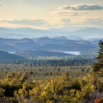
Studying Connectivity in Lake Tahoe Basin

Documenting Barriers & Borders
Fences, walls, and jurisdictional lines don’t mean anything to wildlife — but they shape where animals can and can’t go. Our work documents the barriers fragmenting the Wildways and identifies where solutions are needed most.
Explore Across BoundariesMapping the Border Wall in Arizona and New Mexico
458 miles of border wall were built between the US and Mexico between 2017 and 2021. The environmental damage is severe. This interactive map highlights six priority restoration areas in Arizona and New Mexico.

Mapping Roads & Crossings
Roads kill over a billion animals across North America every year. We’re working to show where that toll is highest and where wildlife crossings can restore safe passage along the Wildways.
Explore Wildlife Crossings


Put the Data to Work
Your support funds the field research that shows us where to act next.
Donate Today