Daunted Courage, Part I
When John Davis invited my husband, Robert, and me to float the Missouri River with nature-loving friends, I initially pooh-poohed the idea. Robert and I were planning a road trip to Alberta’s Jasper National Park, where we’d hoped to watch grizzly bears digging for glacier lilies and perhaps nursing their cubs. We’d already visited Banff to the south—even considered living there once—but Jasper remained on our short-list of places to see. Besides, I knew nothing about the Missouri River, which sounded a little…tame.

We were hoping to see grizzly bears like this one if we went to Jasper National Park. Photo: William C. Gladish
“Where will the float begin?” I asked John on the phone, picturing a put-in near St. Louis next to a crowded creemee stand. This idea seemed out of character for John, who has trekked across most of the wildest landscapes in North America to raise awareness for conservation. Maybe he was craving some southern comfort after a long winter in the Adirondacks. Or he had other business to attend to in Missouri and figured he’d do some scouting while he was there.
“Near the headwaters in Montana,”John replied, adding something about dispersal corridors for cougars. Montana? Does the Missouri run that far north? I wondered, trying to leaf through the atlas that was yellowing in my brain. Clearly, I needed to brush up on my geography. But my curiosity was piqued.
Up the Missouri, 1804
Thomas Jefferson knew even less about the Upper Missouri than I did. When he took office as president in 1801, the United States ended at the Mississippi River, whose confluence with the Missouri was a gateway to who-knows-what. Jefferson’s hunger to explore the terra incognita between the Mississippi and the Pacific would change the course of American history, and also the fate of native peoples and wildlife in the American West.
![Lewis and Clark on the Lower Columbia, painting by Charles Marion Russel. Credit: Charles Marion Russell [Public domain], via Wikimedia Commons](https://images.squarespace-cdn.com/content/v1/60b7e4e41506593f7f926fe7/1632772845881-T1HD613ZXT834GF25KJZ/DauntedCourage2.jpeg)
Lewis and Clark on the Lower Columbia, painting by Charles Marion Russel. Credit: Charles Marion Russell [Public domain], via Wikimedia Commons
On July 4, 1803, the date Jefferson announced the Louisiana Purchase, he officially sanctioned Meriwether Lewis to lead the Corps of Discovery, which would later become known as the Lewis and Clark Expedition. Author Stephen Ambrose describes Jefferson’s motivations in his bestselling book, Undaunted Courage: “Beyond the fur trade and other commerce, beyond the acquisition of knowledge, Jefferson…wanted to tie the two coasts together, using the Missouri-Columbia waterway to form the knot, in order to create a continent-wide empire for the United States.”
Lewis and Clark reached the Upper Missouri in May 1805, a year after departing Camp Dubois in—where else?—St. Louis (though I doubt they found a cremee stand). Unlike most contemporary canoeists, Lewis and Clark’s crew rowed, poled, and pulled their boats against the river’s current, which generally ran at 5 miles per hour. Nearly 4 dozen men traveled in 2 dugout canoes (called pirogues) and a 55-foot keelboat loaded with tons of food, whiskey, guns, and other supplies. Amazingly, they progressed 10 miles or more a day, occasionally doubling this speed if the region’s notoriously strong winds worked in their favor.
The more I read, the more my initial concern about the Missouri River being boring was usurped by excitement—and worries. Robert and I had paddled plenty of lakes when we lived back East, and I felt comfortable on flat water, but I’d never taken a multi-day canoe trip down a major river. Our husky-mix, Alder, sidekick on all our backcountry adventures, had been in a canoe only twice, and both times he’d barked at every passing buoy or branch like we were under siege. And wouldn’t the headwaters of the Missouri be cold in May—as in, Rocky Mountain snowmelt?
![William Clark’s notebook sketch of the expedition’s keelboat, 1804. Credit: William Clark [Public domain], via Wikimedia Commons](https://images.squarespace-cdn.com/content/v1/60b7e4e41506593f7f926fe7/1632772881589-WAHP16CLOB5H2EF6IIDU/DauntedCourage3.jpeg)
William Clark’s notebook sketch of the expedition’s keelboat, 1804. Credit: William Clark [Public domain], via Wikimedia Commons
Still, if Lewis and Clark could travel the Missouri upstream in a monster rowboat overloaded with gear, how hard could it be to float downstream in a 17-foot Kevlar canoe?
Okay, John. We’re in.
Down the Missouri, 2017
After a Wildlands meeting in Utah, John, Kim Crumbo, and I piled into Kim’s pick-up to drive the 10 hours north to our Montana destination.
At Kim’s home near Salt Lake, we stuffed the truck’s flatbed with several bags of food, a supersized ice chest, multiple tents, and 3 unassembled boats: a burly Domar river raft, a surprisingly compact folding kayak, and John’s ultra-light packraft—a solo inflatable so tiny I’d be hesitant to use it in a swimming pool. But John has an exceptional tolerance for discomfort. He spent the entire road trip jammed into Kim’s jump seat with a jumbo bag of pretzels and a thermos of cold coffee, claiming that the former tempers the diuretic effects of the latter.

Alder is on high alert during his “test ride” on Puget Sound. Photo: Robert Long
By the time we crawled out of the cab in Montana, we were ready for action. Almost. We met up with Robert at a hotel in Helena that night, and hit the dusty road to Coal Banks Landing early the following morning.
107 miles.
That was the distance between Coal Banks Landing and James Kipp Recreation Area, the projected endpoint of our journey. We’d be floating the lower 2 sections of the BLM’s Upper Missouri River Breaks National Monument—the White Cliffs section and the Missouri Breaks (or Badlands). Flanked by sandstone cliffs and steep canyon walls, these were generally considered to be the more wild and scenic sections of the Upper Missouri National Wild and Scenic River, which began 42 miles upstream.
There were 10 of us total, plus Alder. We were an eclectic clan of conservationists, several of whom had rafted Utah’s Green River together 4 years back. I was nervous about that outing, too, which marked my first time running rapids. But then, like now, our group possessed a secret weapon whose presence assured me I’d be safe—a weapon for whom Lewis and Clark would have no doubt traded a year’s supply of whiskey: Captain Crumbo.

John Davis in his packraft. Photo: Paula MacKay
Kim Crumbo is no stranger to physical hardship. At almost 70 years young, his background as a Navy SEAL and a professional river guide in the Grand Canyon ripples through his granite-solid body. Prior to 2 deployments in Vietnam with SEAL Team 1, Kim trained near San Diego, where his “quality time in Camp Pendleton” included being dropped off in the scrubland for a week with “absolutely nothing.” But that was apparently a vacation compared to the Hell Week of his Basic Underwater Demolition course, during which Kim and the other sleep-deprived members of his cohort were required to jump into the bone-chilling Bay if they nodded off under the December night sky. Five days floating the Upper Missouri with friends? Kim could, well, do that in his sleep.
Captain Crumbo was accompanied by 3 top-notch first mates—his brother Mark and their old buddies Denny Haskew and Don Sharlow, all of whom also had “Colorado River guide” on their résumés. Dave Parsons, former Mexican wolf biologist with the U.S. Fish and Wildlife Service, had long since earned his stripes on the water as well, and John had run Class 3 rapids in that dinky rubber ducky of his. Throw in 2 ultrafit women—performance artist/master food planner, Abbie Powers, and Mark’s yogi-teacher wife, Karin, and we had our own shining crew.

Map showing Upper Missouri Breaks National Monument. Credit: Bureau of Land Management
Muddy Waters
I sat at a cement picnic table in the partial shade of a cottonwood, trying not to look too hard at the murky water zipping by just beyond the bank. A few of us were waiting at Coal Banks Landing while the others shuttled cars to Kipp. The cottonwoods were key, as we’d be here seeking respite from the hot sun for most of the day.
Glancing around, I could almost convince myself to be calm. The landing got its name from the band of lignite coal passing through the surrounding hillsides—dry, rolling rangelands for as far as the eye could see, until they eventually butted up against larger mountains to the south. Barn swallows flitted about in the soft breeze, which carried the courtship song of yellow warblers and other birds, along with the distant lowing of cows. Kim and Denny lazily futzed with their boats, cold drinks in hand, while Karin practiced yoga in another clump of trees. Even Alder relaxed into his 6-hour layover, snapping at flies and taking quick dips to wet his husky fur.
Occasionally, a vehicle emerged from a cloud of dirt to transport other boaters. Early afternoon, I watched an elderly man release his black Lab from the passenger seat of his pick-up, the dog immediately squatting for a much-needed pee.

Captain Crumbo. Photo: Paula MacKay
“G’day, ma’am.” The man tipped his cowboy hat as I approached with Alder in-tow; I wanted the dogs to meet in case we ran into each other on the river. Turns out this stately fellow had driven all the way from Texas, having floated the Upper Missouri many times to hunt flint in the adjoining hills. “Yes ma’am, this is special country,” he said, noting that this would be his first adventure with his new “lady-friend”—whom he’d recently rescued from a shelter back home. “I couldn’t resist that beautiful face.” We both smiled as Alder and the travel-weary Lab wrestled like littermates in the weeds.
Later, a vanload of teenagers showed up with their 20-something guides, who bossed the kids around from the sidelines and told them they’d get more instructions when they were on the water. I overheard one of the teens say she’d never been in a canoe before, to which her companion admitted that he hadn’t, either.
These folks weren’t the hard-core river runners I’d imagined paddling the mighty Missouri; maybe I’d be okay on this trip after all. That’s what everyone kept telling me, anyway. “You’ll be fine as long as you respect the current,” said the ranger on-site, who reminded me that the river was flowing fast due to excessive spring run-off. I prodded him to recount last year’s sole rescue: a paddler and his dog had run into a sweeper when they ventured downstream after dark. With his canoe pinned against a log by the rushing water, the man had somehow managed to swim beneath the broken tree and climb safely to shore. He and the dog were cold but uninjured when the rangers picked them up the following morning.
Check. No paddling at night.
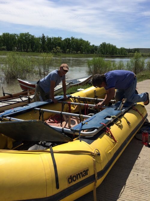
Captain Crumbo and Denny Haskew pack the Domar raft at the launch. Photo: Paula MacKay
As the afternoon came to a close, I saw a middle-aged couple hoisting their motorboat onto a trailer after a day on the river. “How was it?” I asked the woman, who wore a bulky walking cast over her otherwise bare foot. Beautiful, she replied, affirming that this section of the Missouri was free of whitewater. Her enthusiastic expression changed when I pointed to our paper-thin Wenonah resting in the grass. “Oh, I would never do this in a canoe,” she said, shaking her head emphatically. “But that’s just me.”
The woman’s husband yanked on the trailer one last time before turning to join the conversation, his sunburned face looking disconcertingly serious. “Be careful out there—have you heard about tomorrow’s forecast? We’re supposed to get 60-mile-an-hour winds.”
( continued )